


|
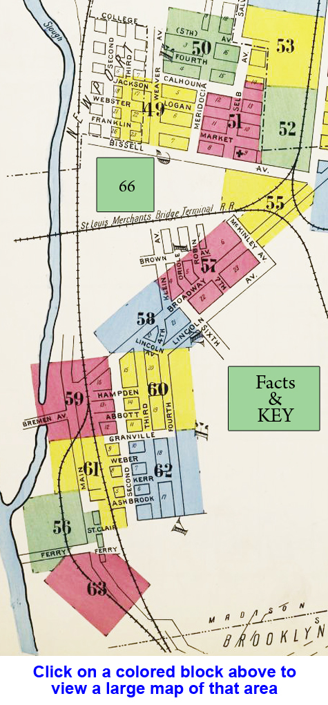
A set of maps has been found which shows amazing details and gives insight of the then growing city of Venice in 1907. The population then was 3,500. The maps, known for their accuracy, show the locations and relative sizes of every house, building and other structures in the city with many details including the type of construction used and location of any fire alarms and firewalls, if any, and locations of fire hydrants and other details important to fire insurance companies. (The following is taken from the Wikipedia entry on Sanborn Maps.) The Sanborn Maps were originally created for assessing fire insurance liability in urbanized areas in the United States. The maps include detailed information regarding town and building information in approximately 12,000 US towns and cities from 1867 to 2007. Author Kim Keister describes the legacy of Sanborn maps: "Stated simply, the Sanborn maps survive as a guide to American urbanization that is unrivaled by other cartography and, for that matter, by few documentary resources of any kind." They are a highly useful resource for historical research, planning, preservation, genealogical research, sociological studies and research of urban geography. Mapping for insurance, and specifically fire insurance, purposes had existed for a century prior to the emergence of the Sanborn Company, first beginning in London in the late 18th century with the Phoenix Assurance Company.[2] In the decades following the end of the Civil War, fire insurance mapping grew rapidly, mirroring the flourish of growth in the country, the rebuilding of the South and massive westward expansion. Factors such as the Homestead Act, railroad construction, the Second Industrial Revolution and massive immigration to the United States all fostered huge population growths, urbanization, and heightened demand for mapping. Daniel Alfred Sanborn, a civil engineer and surveyor, began working on fire insurance maps in 1866. That year, he was contracted by the Aetna Insurance Company to prepare maps of areas in Tennessee. About the same time, he developed similar maps of Boston, published as Insurance Map of Boston, Volume 1, 1867. Seeing a lucrative market for these types of map, he established the D. A. Sanborn National Insurance Diagram Bureau in New York City to publish the Boston atlas and develop and sell maps of additional areas. Within several decades, the company became the largest and most successful American map company. This growth came about through savvy management and the buyout of competing firms. Company headquarters moved to 629 Fifth Avenue in northern Pelham, New York, but there were also regional offices in San Francisco, Chicago, and Atlanta. The Sanborn Company sent out legions of surveyors to record the building footprints and relevant details about these buildings in all major urbanized areas regarding their fire liability. At its peak in the interwar period, the company employed about 700 people, including about 300 field surveyors and 400 cartographers, printers, managers, salesmen, and support staff. It was because of these details and the accuracy of the Sanborn maps, coupled with the Sanborn Companys standardized symbolization and aesthetic appeal that made the Sanborn Company so successful and their maps so widely utilized. The maps were originally created solely for insurance assessment purposes; it was said that at one time, insurance companies and their agents, relied upon them with almost blind faith. The maps were utilized by insurance companies to determine the liability of a particular building through all the information included on the map; building material, proximity to other buildings and fire departments, the location of gas lines et cetera. The very decision as to how much, if any insurance was to be offered to a customer was often determined solely through the use of a Sanborn map. The maps also allowed insurance companies to visualize their entire coverage areas; when an agent sold a policy he could color in the corresponding building on the map and thus visualize the companies coverage of an area. To view the Sanborn maps for Venice in .pdf form, click HERE. Included are several enlargements of the map details. You can also view Sanborn Maps for other Illinois urban areas by visiting the University of Illinois library website by clicking HERE.
|
 "Cover")  You may click on either image to view a larger version. You can easily zoom in to read street names and see the details included in all three cities. If you would like to view an even larger version of the map, you may click HERE, but the file is very large and may take a while to load. The Tri-Cities area looked quite different in 1906 from the communities we know today. The map is actually three pages from the "Standard Atlas of Madison County Illinois" published in 1906 that have been pieced together. Since all of the artwork was done by hand, the three sheets don't mesh perfectly together, but the combined map is still easily viewed. The larger version of the map is huge and may take a while to load for some. 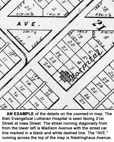 There is great detail on the map and you may find some of the street names, even those in Venice, to be quite different from what they are today. You can also see where the original St. Elizabeth's Hospital (at this time it was known as the Evangelical Lutheran Hospital) was located facing 21st Street on the corner of Iowa Street. Also the intersection of Niedringhaus Avenue and 20th Street was envisioned quite different than it is today.
Another interesting thing found on the map is the extension of Klein Street towards Brooklyn and its intersection with Fourth Street in the area where the former Lincoln High School is located and now operated by the Venice School District as a Kindergarten through 12th Grade school. Of course, neither the McKinley Bridge nor the power house had been built yet and you will notice two city blocks laid out where the viaduct and railroad property exist today. The old Venice Public School is marked as is St. Mark's Church and School. The maps allow us to see what the early city fathers had planned for their respective cities and also show how the railroads and street cars were an important part of all three communities in the early 20th Century. |
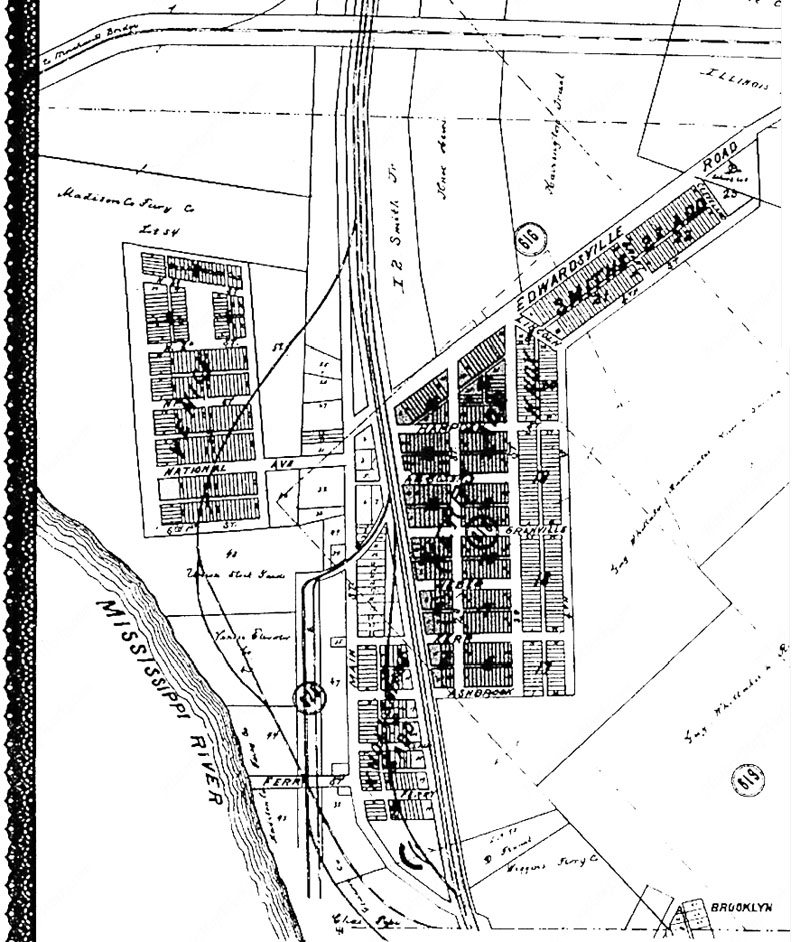 This is a map of the Venice area published in 1892. Note that Broadway is marked "Edwardsville Road" and the McKinley Bridge is missing. It was built in 1910. Also Lincoln Ave. is marked 4th St. (No copyright intended or implied) |

)